Saturday, 18 October 2014

Heart of England Way - Part 1 - Milford to Lichfield

With a day's holiday booked and unseasonally warm weather for the time of year, it was time to decide what to do.  Let's have a look at the Heart of England Way (HoEW) I thought.  It's a 102 mile route from Cannock Chase in Staffordshire to the Cotswolds in Gloucestershire. 

I've spent quite a few days on Cannock Chase over the past couple of years shadowing kids doing their Duke of Edinburgh Award walks but have never had a long walk there so quite fancied the idea.

An easy trip up the M6 brought me to Milford Common car park, the start of the walk.  A warning sign said that the car park closes at dusk.  That sounds a bit worrying and seems dependent on the interpretation of dusk by the people with the key. I'd better get a move on.

Start of the Heart of England Way on Milford Common
 
The paths on the Chase are full of pebbles.  I used to think the paths had been made using beach pebbles but now realise that the whole area was formed in the ice age when the pebbles and sand were dumped up here and this is what leads to the unusual landscape and nature.


Youv'e been warned.  I didn't test the theory

This 16 mile route from Milford to Lichfield was easy to follow, especially as I had loaded a GPX file of the path into my GPS before leaving home.  So armed with map and GPS I had no excuses. I took an extra couple of diversions off the main path to climb a few hills making it probably an 18 mile day in total.


The Polish War Memorial
There is a good bus service form Lichfield back to Milford that runs every 30 minutes on weekdays, but be warned that the 4.05 bus is full of noisy schoolchildren!


Now how do I get past these!
Apologies for the fairly random order in which the pictures appear in this post!  Try as I might I just cant seem to get them reordered in any sensible manner!


Scenes across the Chase


A promising start to the day - disciduous woodland


Good farming practice - ploughing and planting the field but then marking where the footpath is to make it easy for walkers to follow.


I wonder if you can guess what the nearby pub was called?


Time to cross the cabbage field


Autumn colours on the Chase


Something to wash down the sanwiches


An old friend that I've visited previously

 
Lunchtime stop - sandwiches and a geocache


Pretty good signage along the path all day


Lichfield - Erasmus Darwin House


Cannock Chase Visitor Centre - they serve a fine selection of cakes!.


Sunday, 12 October 2014

Birmingham to Coventry

I fancied a walk this weekend but having driven quite a bit in the past couple of weekends I thought it may be nice to catch the bus and explore some of my local environment.  How about trying to walk from Birmingham Cathedral to Coventry Cathedral I thought.  There's no official route but a quick look at the map made me realise there could be a decent route along the Grand Union Canal out of Birmingham and then across the fields and parks into Coventry.  Here's some photos from the day.

Birmingham Cathedral - my starting point.

New and Old - Moor St Station and Selfridges

Old Victorian Public Toilets on corner of Great Barr Street

My entry point onto the Grand Union Canal
The urban canal system in  the Birmingham suburbs

A Birmingham church

Some nice attempts to add signage to the canal

Te boundary between urban and rural canal

Signage - close to home and far away


Tysley Incinerator


Heron in flight

Heron at rest

Time for elevenses in Orton

Canal looking nice now in the midday milky sunshine

Naughty farmer ploughing over the footpath

Under the flightpath for Birmingham Airport


Over the M40


Time for tea and cake in Hampden in Arden - nice cafe, warm welcome to walkers


An old mill stone in Hampden in Arden


The only road stretch I encountered, leaving Hampden towards Meriden

The girls of Meriden

Afternoon coffee break


Meriden church

Farmers have been busy recently evidently

Two passing walkers pointed to this bird across the field saying it was a Red Kite, an unusual visitor to Warwickshire.

Some frisky friends


Pickford Green


Now that's what I call an old house

Coventry coming into sight

An arty tree

Allesley Park


Wild flower bed in Allesley Park


Lake View Park - my local park

Spon End

Spon Street, Coventry

Lady Godiva, Coventry

Coventry Council House


Coventry Cathedral


A celebratory local pint of beer
The twenty mile walk took me eight hours in total with four stops, three in cafes and one at my own house in Coventry before the final push into the centre of Coventry.  The weather forecast was for showers but luckily none fell and I had a dry day with pleasant walking temperature.


Saturday, 10 November 2012

The Geosquare Cache Series


I have recently launched a new series of caches and called it the Geosquare series.


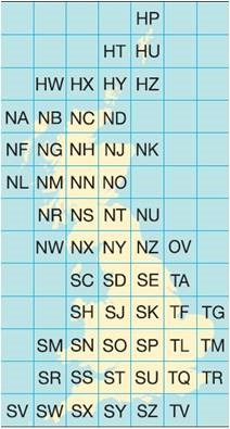
The Ordnance Survey (OS) National Grid provides a unique reference system, which can be seen on all Ordnance Survey maps of Great Britain. Great Britain is covered by 100 kilometre grid squares, each grid square is identified by two letters. On Ordnance Survey maps these squares are further divided into smaller 1 km squares by grid lines representing 1 kilometre spacing, each numbered from 0 to 99 from the south-west corner, in an easterly (left to right) and northerly (upwards) direction.


In the Geosquare series the cache is named after the 1 km square in which it is placed. Others are welcome to add to the series, using the logo, sidebar and description.


The first cache in the series was Geosquare SP2382 - Middle England and is as the name suggests in the middle of England - in Meriden. As of November 2012 there are six caches in the Geosquare series.


I should emphasise that the idea is not to saturate a 100 km square with Geosquare caches. The quality of caches needs to be maintained, and above all the safety of the geocache needs to be born in mind.

I've got a lot of ideas of how to develop the series, in particular with challenges e.g. finding five Geosquare cahes in a row:


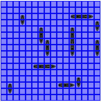
How about Geosquare Battleship, where the idea would be to find adjoining Geosquare caches in a 100 km square matching the Battleship game rules.


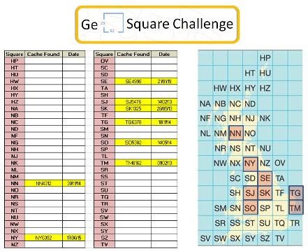
If the idea takes off then the ultimate Geosquare Challenge would be to find a Geosquare cache in each of the 100 Km squares:-